|
|
|
 |
|||||||||
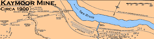
| Located just below the current Route 19 New River Bridge, Kaymoor, WV housed an impressive, yet typical New River coal field incline mine. The Sewell coal seam laid in a bed about 560 feet above the river level. To get the coal from the mine mouth to the railroad, the miners relied on a gravity incline.
At the river level, the C&O mainline had a spur to the Kaymoor tipple. Several coke ovens and a small town were at this level too. Now, nearly everything is gone. Fortunately, the HAER thoroughly documented this location |
Below are reduced drawings of the mine tipple and the track plan. The HAER has additional larger drawings of these and the rest of the mine facilities including perspective views of the mine sorting apparatus. Look for the following citiation.
Kaymoor Coal Mine, S. side of New River,upstream of N.R.G. Bridge, FAYETTEVILLE VIC., Fayette County, WV.16 measured drawings, 76 b&w photos, 33 data pages plus cover page, 5 photo caption pages, 3 color transparencies |
||||||||
 |
 |
||||||||
| Return to Locations | Return to Maps | ||||||||