|
|
|
 |
Grade profile comparison of eastern coal hauling railroads in West Virginia. Note that in general the C&O had the gentlest route through West Virginia. Although not shown on the chart, the C&O mainline also had less curvature than the N&W or Virginian. |
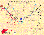 |
Clickable map showing the New River and part of the Alleghany Subdivision. |
 |
1:100,000 Topographic Map of the NRSD from Sewell to Quinnimont. (Click to enlarge. Warning very large file) A complete set of USGS topographic maps of WV in Digital Raster Graphics form is available for downloading free from the West Virginia Division of Environmental Protection |