|
EXCURSION TO WEST VIRGINIA
by Eric W. Hansmann
In July of 1995, some friends and I were discussing the Western Maryland Railway mainline through West Virginia. Since we were all railfans and enjoyed a good adventure, someone posed the question of biking the grade through Blackwater River canyon. A good question, we all agreed. A fun trip, most definitely. We picked Sunday August 6th for the trip and started planning. In late July, we were tracking hurricane Erin to see what sort of weather we may expect. On August 4th, the trip was canceled. It looked like solid rain for the whole weekend.
My phone rang at 10:30 am, Sunday August 6th. It was Jack, an adventurer not known to buckle under to a little weather.
"I've been checking the Weather Channel and it looks like the worst is over. I think it's going to be a perfect day for this," he said as I munched on my shredded wheat.
"Okay, let's go," was my reply. I figured we might see some sights along the Cheat River even if we didn't ride.
By 12:30 pm, we were heading east out of Morgantown on I-68 under light gray skies. At Bruceton Mills, we exited onto State Route 26 and headed south toward Albright. Soon we were along the Cheat River and at Albright we turned onto the Camp Dawson road. The river was showing the effects of seven inches of rainfall in a 48-hour period. It was a wild, churning mass of brown water hiding all but the largest boulders on the riverbed. Before long, we were making a right onto State Route 7, crossing the Cheat, and making a left onto State Route 72, which would take us all the way to Parsons. The trip so far was affording some nice scenery.
Arriving at Parsons, the weather looked encouraging as we made a pit stop and inspected the Western Maryland Railway depot. After some yawning and stretching, we swung the van around and headed to Hendricks. We arrived moments later with the strange feeling that time has somehow stopped here in Tucker County. The WM bridge over the Blackwater River looks almost freshly painted. None of the lettering seems to have faded. All this railfan needed to see were a brace of Western Maryland diesels leaning into the curve and attacking the grade with a fully loaded train.
Jack pulled the van off at a wide spot in the road, and we proceeded to unload the two bikes and strap on repair tools, food, first aid and helmets.
"You do realize what's ahead of us today, don't you?" he asked with a grin.
"I understand from here to Thomas is ten miles. Pretty much the entire trip will be on a three percent grade, and it is all uphill," was my response, having read and reread the info about the grade in several different books. "I also understand that few people bother to ride this right of way because it isn't developed or marked."
"Think you'll make it to Thomas?" Jack inquired.
"I sure hope so," I quipped.
After double checking our gear and bikes, we crossed the highway and headed around the curve up the grade, paralleling the raging Blackwater River for the first half-mile or so. I felt pretty good until the grade really kicked in about a mile out of Hendricks near where Hickory Lick tumbles off of the mountain. Today it wasn't tumbling, it was roaring. The blast of cool air coming from the stream felt good. We continued onward past Spruce Lick, and Flat Rock Run. Around this area was Lime Rock Switch. It was wide enough for two tracks and as we pedaled on, we noticed an even steeper grade climbing the mountain, a former logging railroad grade, now a hiking trail. Soon, the mainline started curving sharply and we could hear the roar of Big Run.
Imagine a white sheet of water coming off of a steep mountainside on a thirty to forty degree slope, put only a couple large boulders here and there in the stream, and you have a basic idea of what Big Run looked like on that day. Jack and I decided to take a break and get a few photos. At one time, the railroad had a trestle spanning the creek valley. Now it is an immense fill about fifty feet from water level up to the rail, with a large stone culvert directing the water under the mainline. Looking down to the Blackwater River, I could hardly see the water through the thick forest of trees. From the railroad grade, the mountainside plunges steeply down to the river.
Starting up again at Big Run, the odometer read 3.94 miles since our start. Further on up the mountain, my legs felt like lead. We stopped at Tub Run and again at Finley Run. I find it hard to imagine the initial survey crews cutting through this wilderness to plot this railroad one hundred years ago. Following the surveyors, the construction crews cleared the way and built the grade with nothing but picks, shovels, mules and black powder. Track crews were next, putting down ties and spiking the rails into place. I was visualizing this when Jack stopped and walked over to a clear spot between a couple trees near the edge. As I walked over, a panoramic view opened right up. Out over that edge, the East Fork of the Blackwater River had worn away a valley on the other side of the canyon. The churning brown waters of the forks met at a point three hundred feet below us. Jack and I just stood there taking in the amazing view. We hadn't realized how far up the mountain we were from the river.
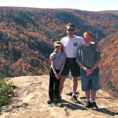
Danica, Bernard and Chase Kempinski pose at Blackwater Falls State Park. Behind them is the canyon that Eric describes.
 |
|
After a power snack, we pushed on to our destination. The odometer was just under eight miles. I was concentrating on my slow rate of travel when another roar began to fill my ears and kept getting louder as we pedaled. We were on an inside curve hugging the mountain when I saw Little Falls through the trees ahead. It really didn't look very little. I knew our location from railroad photos I had memorized, but many trees and bushes had grown over the years to obscure the view. We rounded the corner right at the falls and found ourselves in Douglas. Little remains of the once busy mining town, but it sure was nice to see a house. The classic company store is long gone. |
The town of Thomas is visible for quite a while before you actually get there, which is a real curse after pedaling 91/2 miles uphill. Many older photos reveal Thomas to be quite a bustling town with an opera house, hotels, many downtown business, scads of houses covering the hillside, a huge company store, and a large locomotive facility for the railroad. Present day Thomas has a starkly different environment with no railroad, fewer houses, a vacant company store, and many empty storefronts and vacant lots. Jack and I rode up the old Francis Branch towards Davis, then followed pavement to our original path into town.
Back down on the grade, we took one last break. It was 6 PM and 68 cool degrees on the mountain. It had been a picture perfect day for the trip. We figured it took about three hours to come upgrade with the rest stops to check out "stuff." Fifty minutes after leaving Thomas, and screaming down the mountain, we were back at Hendricks loading up the van and heading home.
For anyone interested in a bike trip in the Mountain State, this is a great one. Currently, the roadbed is in good shape. A couple retaining walls have collapsed, but very little roadbed has eroded. The condition of the surface reminded me of a wide, old, gravel driveway: fairly well packed with a strip of weeds growing down the center. If you don't want to do the uphill run, bring a few buddies and a couple vans and park one at each end. This will give you time to enjoy the scenery and pick some wild blackberries. Hiking is another option. Be sure to go early in the day and watch out for the wildlife.
|
